REC  00:00:00
ANOMALY DETECTED
ΔT –18.4°C
Active mission: Natural gas pipeline monitoring
Altitude
Speed
Range rem.
LTE/5G · LIVE FEED ACTIVE
1,500km
Range per mission
4–6L
Fuel per patrol
100%
Autonomous flight
LTE/5G
Live connectivity
Long-range civil UAV systems

One Aircraft.
Fifteen HundredKilometres.

Complete long-range unmanned aircraft programs for civil missions. Infrastructure monitoring, wildfire response, public safety and agriculture. Not a drone in a box.

Who we are

Aerial Capability,
Delivered as a Whole.

When the territory you are responsible for stretches across hundreds of kilometres — a pipeline corridor, a forested region, a national border of farmland — short-range drones and occasional helicopter flights stop being an answer. They become a logistics problem.

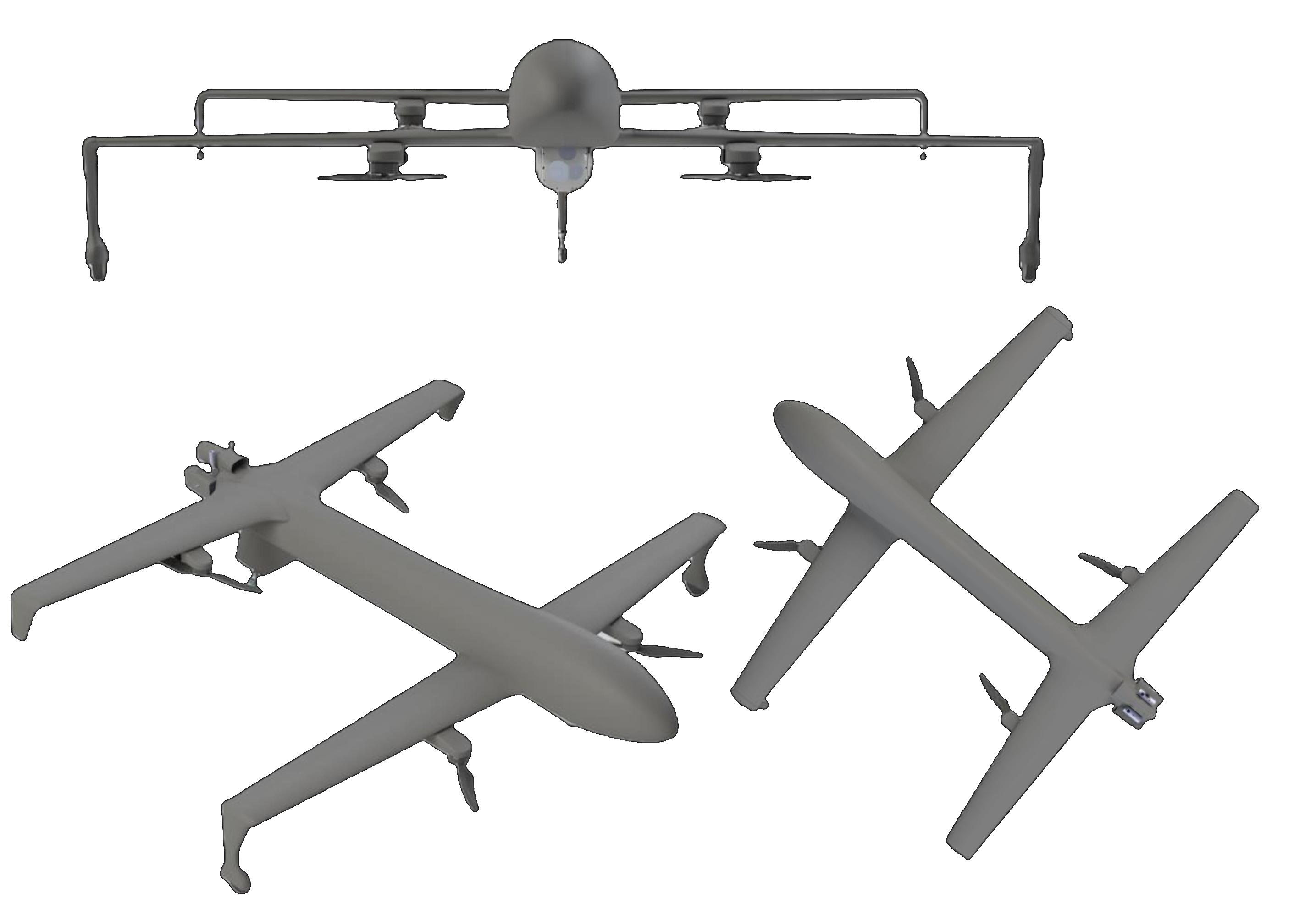
Sky Drone Technologies exists for precisely this scale. We are a Bratislava-based systems company that delivers complete long-range unmanned aviation programs for civil operators. Our platforms are gasoline-powered fixed-wing aircraft with operational ranges of 1,500 kilometres and more.

We do not sell aircraft and walk away. What you receive is not equipment. It is a capability.

01
Concept to capability
Every engagement covers the full arc: concept development, payload selection, ground infrastructure, aviation documentation, operator training and entry into service.
02
Proven in the field
Our platforms have accumulated thousands of flight hours in some of the most demanding long-range operational programs in the world.
03
Built for your scale
Energy and utility companies, fire and rescue services, public safety agencies and large agricultural enterprises — we operate at regional scale.
Platform Visual
Sky Drone UAV Platform — three views
~1,500 km
Operational Range
Autonomous
Navigation
LTE / 5G
Connectivity
~4–6 L
Fuel per Mission
The platform

Built for Distance.
Engineered for Endurance.

At the heart of every Sky Drone Technologies program is a long-range, gasoline-powered, fixed-wing unmanned aircraft. The choice of propulsion and airframe is deliberate — it is what separates a genuine regional monitoring capability from a fleet of toys.

ConfigurationLong-range fixed-wing, gasoline propulsion
Operational range~1,500–1,600 km
Fuel consumption~4–6 L per mission
Operating altitudefrom ~150 m
GuidanceFully autonomous, geolocation-based
ConnectivityLTE / 5G — live video, telemetry, oversight
Operational set2 aircraft + spare-parts package
Range that changes the operating model
With an operational range of approximately 1,500 to 1,600 kilometres, a single aircraft can patrol an entire pipeline corridor, river basin or regional fire zone in one mission — and return. Battery platforms typically manage around 120 km; multirotor drones rarely exceed 30.
Autonomy as standard
The aircraft flies its assigned route autonomously, guided by precise geolocation. It does not require continuous manual piloting. Your operators supervise the mission; they do not wrestle with it.
Honest economics
A full long-range patrol consumes approximately four to six litres of gasoline — a fraction of helicopter cost. Stable performance in cold weather, where battery systems fail exactly when monitoring matters most.
A stable sensor platform
Flying at approximately 150 metres, the aircraft provides a steady, repeatable vantage point — close enough for detection-grade detail, high enough for efficient corridor coverage.
Applications

Four Missions.
One Capability.

Flagship

Hundreds of Kilometres of Pipeline. One Aircraft Overhead.

Linear infrastructure — gas and oil pipelines, power transmission corridors, railways, water mains — is the natural mission for long-range fixed-wing aircraft. A corridor that would demand a chain of ground stations and a small fleet of short-range drones can be flown by a single aircraft, repeatedly and on schedule.

We designed our reference concept around a real 480-kilometre national gas transmission corridor: two aircraft, two ground stations, AI analytics and live LTE connectivity covering the entire route.

What the system detects
Surface changes and vegetation anomalies indicating leakage or ground movement
Unauthorised construction, excavation and third-party interference
Encroachment, erosion, flooding and landslide risk along the corridor
Condition of crossings, valve stations and above-ground installations
Sensors & Intelligence

The Aircraft Carries.
The Sensors See.
The Software Understands.

A monitoring system is only as good as what it detects. Sky Drone Technologies programs are built payload-first: we begin with what you need to find, then configure the aircraft around it.

AI-assisted analysis

Hours of corridor footage are useless if a human must watch every frame. Our delivery includes AI software for automated anomaly detection, leak- and foreign-object screening, change detection across repeated flights, and lifetime data management. Your specialists review flagged events — not raw video.

Live connectivity

Through LTE/5G integration, the system provides live video transmission, continuous position tracking, full telemetry access and real-time mission oversight. The aircraft may be autonomous; you are never out of the picture.

Multispectral
Vegetation indices, surface change, moisture signatures — the workhorse of pipeline, environmental and agricultural detection.
SWIR
Short-wave infrared detection beyond the visible spectrum, including surface anomalies associated with leaks and material changes.
EO & Thermal
High-resolution inspection detail, hotspot detection, day/night observation.
Mission-specific
Additional payload options configured per mission profile. The right sensor for the right problem.
480 km
Reference corridor — single aircraft, two stations
Our reference concept, a real national gas transmission corridor.
Ground segment

A Complete Operating Environment.
Fixed or Mobile.

Every program includes the ground infrastructure that turns aircraft into an operating unit. A typical regional deployment is remarkably lean — the entire footprint for continuous monitoring of a corridor several hundred kilometres long.

Comparison
Multirotor fleetStation every 30 km
SDT approach2 stations, 2 strips, 2 aircraft
01
Building-based control centre
An existing structure adapted into a fully equipped station with communications, operator workspace, maintenance facilities, fuel storage and refuelling.
02
Mobile control centre in a van
The same capability, mounted and movable. Deploy the aircraft from wherever the mission requires.
03
Two take-off and landing strips
Approximately 120 metres of asphalt, 30 metres wide, each. Minimal footprint for a regional capability.
04
Operational aircraft set
Two aircraft plus a comprehensive spare-parts package for sustained availability.
05
AI analysis software
Automated anomaly detection, change detection across repeated flights, and lifetime data management.
06
LTE operator agreement
Live video transmission, continuous position tracking and real-time mission oversight.
Why fixed-wing

The Physics
of Coverage.

Three platform classes. One obvious conclusion.

Battery fixed-wing
~120 km
Limited
Chain of ground stations required
Frequent charging cycles
Cold weather cuts range and reliability
Regional coverage requires 15+ stations
Multirotor drones
~20–30 km
Inadequate
Infrastructure every 30 km
Large ground crews in constant motion
Airframes wear out under intensive use
No viable regional coverage
Sky Drone Technologies
1,500+ km
Designed for this
Two stations, two strips, two aircraft
Lower cost than helicopters
Less infrastructure than drone fleets
Stable performance through winter
Turnkey delivery

We Don't Deliver Drones.
We Deliver a Flying Unit.

An aircraft without permits, trained operators, ground infrastructure and an operating concept is an expensive ornament. Our role is to build the whole capability.

Our aircraft are produced by an established manufacturer whose platforms have accumulated extensive operational flight hours. Manufacturer identity and full technical documentation are disclosed at proposal stage.

01
Concept development
Mission analysis, route design, coverage architecture — before a single component is specified.
02
Technical consultation
Payload selection matched to your detection requirements and budget.
03
Operations design
Patrol schedules, staffing model, data workflows — everything your team needs to run the operation.
04
Documentation & permits
Full project and aviation documentation. Support through the regulatory process from start to finish.
05
Infrastructure preparation
Ground stations, landing strips, connectivity — built and commissioned before handover.
06
Entry into service
Training, commissioning, supervised early operations. We stay until your team is fully operational.
07
Ongoing support
Spares, maintenance frameworks and advisory. A long-term relationship, not a handover and goodbye.
Configurability

Your Territory Is Not Generic.
Neither Is Our System.

No two corridors, regions or estates are alike — and a fixed-spec product is the wrong answer to a variable mission. Every Sky Drone Technologies program is configured per client.

The platform is the constant. Everything around it is built for you.

Payload
MultispectralSWIREO/ThermalCombinations
Ground segment
Fixed buildingMobile vanHybrid
Coverage
Aircraft countStation placementPatrol frequency
Connectivity
LTE/5G integrationOps centre linkData systems
Analytics
AI detection profilesAsset-tunedTerrain-tuned
Scale
Single deploymentMulti-corridorNational program
Begin with a conversation

Tell us about
your territory.

The corridor, the region, the risk you need to see before it becomes a problem. We will respond with a concrete operating concept: aircraft, sensors, ground segment, economics.

Contact
CompanySky Drone Technologies s.r.o.
LocationBratislava, Slovakia
© Sky Drone Technologies s.r.o. — Long-range unmanned aviation programs for civil missions.Bratislava, Slovakia